Environment

Environment
Undertow Currents on Lake Erie: The Dangers Facing Vacationers
The tragedy occurred on Sunday when a man, whose identity has not yet been established, disappeared into the turbulent waters of the lake. On Tuesday evening, a body was found near Edgewater Beach, but there is no official confirmation that it is the missing person. Local resident Zippora Barnes, who witnessed the atmosphere at the beach, shared her sadness: “It's very sad. People come here to relax, enjoy the moment. But you never know what might happen. Finding out that someone has not been found — it just breaks your heart.”Invisible threat beneath the surfaceDespite its scenic beauty, Lake Erie has a complex lakebed topography that facilitates the formation of these dangerous flows. The lake's deepest point reaches 250 feet, but even in coastal areas, strong winds and swift currents can create deadly traps. “When the winds intensify, as they have in recent days, the currents become even more unpredictable,” adds Sakhala.How to survive if pulled into a rip currentSakhala emphasizes: panic is the worst enemy in such a situation. “If you're caught in a rip current, stay calm and try to swim parallel to the shoreline. Currents are usually narrow — a few feet to about a yard wide. If you can't do that, allow the current to carry you but stay afloat,” he advises. This strategy can save lives because fighting against the current only exhausts your strength.The Cleveland National Weather Service issues daily warnings about currents and hazards for small vessels. Sakhala urges everyone planning to visit the beach to check current weather forecasts and warnings. “These dangers will not disappear over the coming months, especially in the warm season when currents become more frequent,” he notes.The community in mourning, but hopefulFor locals like Zippora Barnes, Lake Erie is not just a place to relax but also a source of concern. With two twin children, she plans to enroll them in swimming lessons to prepare for possible dangers. “I pray for the family of the deceased,” she says. “It's a reminder that we need to be careful.”The tragedies on Lake Erie are a harsh lesson in how nature can be both beautiful and merciless. While rescue operations grapple with challenges caused by currents and winds, the Cleveland community urges everyone heading to the beach to stay vigilant. Checking forecasts, knowing survival techniques in currents, and respecting the forces of nature can mean the difference between life and death.
28.08.2025

Environment
From Lake Erie to the Ohio River: Ohio Unveils Its Water Heritage That Shaped America's Destiny, on the Eve of Its 250th Anniversary
While the United States prepares to mark its 250th anniversary in 2026, Ohio, this unassuming but key player in American history, is launching an ambitious project that commemorates the nation's roots. The new highway route from Lake Erie to the Ohio River is not just a tourist trail but a living chronicle of water routes that served as the "highways of hope" for generations of pioneers, industrialists, and dreamers. Developed by the America 250-Ohio commission, this route includes over 150 sites across the state, from majestic lighthouses on the northern shoreline to scenic viewpoints along the southern river bends, inviting travelers to immerse themselves in the heritage that shaped America's economy, culture, and even geopolitics.
The waterways of Ohio have always been more than just geographical features. They were arteries of progress. The Ohio River, stretching 981 miles and being the third-largest in the U.S. by discharge, served as the border between free Northern states and the enslaving South in the pre-Civil War era, becoming a key route for the Underground Railroad — a network that helped thousands of slaves escape to freedom. As I was told by historians from Ohio History Connection during my numerous trips around the region, this river witnessed the first European explorations by Robert de La Salle in 1669, and later became the transportation corridor for the Lewis and Clark expedition, which originated in Pittsburgh. Lake Erie, with its turbulent storms and strategic location, connected the Great Lakes to the Atlantic via the Erie Canal, opened in 1825, revolutionizing trade and making Ohio an industrial hub. "These waters didn't just flow—they built an empire," one of my sources at the National Park Service remarked, emphasizing how Ohio and Erie canals, spanning over 300 miles, accelerated westward expansion, ferrying goods from corn to steel.
Melinda Huntley, commissioner of America 250-Ohio and executive director of the Ohio Travel Association, describes this route as a tribute to those "highways of hope" that "built cities, attracted inventors, created jobs, and united people." "Today, their legacy flows through every scenic overlook, preserved towpath, and community still thriving along their banks," she said in a conversation with the press, her words resonating with a deep understanding of the state where waterways were the foundation for giants like the Wright Brothers or John D. Rockefeller, whose businesses grew along these shores.
The route is organized into seven thematic categories, allowing travelers to tailor their journey to their interests: from boat and ferry rides to Lake Erie lighthouses, canal museums, locks, and natural areas, as well as sites related to water sciences and research. In northeastern Ohio, for example, visitors can view the William G. Mather steamer of 1925 in downtown Cleveland — a relic of the lake freight shipping era, reminiscent of times when Lake Erie was a hub for European immigrants. Further south, the Ohio and Erie Canal Towpath stretches from Cleveland to Tuscarawas County, offering walking trails along historic canals that once transported millions of tons of freight. And in Marietta, near the Ohio River, the Valley Gem Sternwheeler offers cruise rides on a paddlewheel steamboat, recreating the atmosphere of the 19th century when the river was the main artery for pioneers heading west.
This route is the third of six planned by America 250-Ohio, highlighting Ohio’s role in American history. The previous routes — "Ohio’s Aerospace Path," dedicated to aviation (from the Wright Brothers to Neil Armstrong), and "Ohio’s Path of Creativity," celebrating artists, writers, and musicians — have already drawn thousands of visitors, according to the commission. Upcoming are routes dedicated to inventors, transportation, and leaders, including eight U.S. presidents born in Ohio, from William H. Harrison to Warren G. Harding. As an insider covering similar initiatives in other states, I can say: Ohio stands out for its inclusivity, incorporating stories of Native Americans such as Shawnee and Delaware peoples, whose civilizations thrived along these waters for millennia before Europeans arrived.
But this is only part of the grand celebration. Starting January 2026, the state plans monthly themed events focusing on transportation, innovation, arts, and sports. "Ohio Goes to the Movies" is an ambitious project where all 88 counties will showcase films about Ohio and its people, from classics like "Shenandoah" to documentaries about the industrial revolution. Dozens of other events, from waterfront festivals to educational programs in schools, are expected to engage the entire state. The full list is available at america250-ohio.org — a resource becoming the heartbeat of the preparations.
In a world where history often seems remote, this route reminds us: Ohio’s waterways didn’t just flow—they carried the dreams of a nation. As America looks to the future, Ohio offers a journey into the past that inspires reflection on where we are headed next. For travelers, historians, or simply curious souls, it’s a chance to see the heart of America beating in the rhythm of its rivers.
26.08.2025

Environment
Weather forecast: Monday, August 25, noticeable cooling, possible precipitation
Monday, August 25The day promises sunny and warm weather. Temperatures will rise to +28°C, with nighttime dropping to +17°C. No precipitation is expected, gentle breeze, 6–9 km/h. An ideal day for walks and outdoor activities.Sunrise: 6:52Sunset: 20:11Tuesday, August 26Partly cloudy with brief showers in the second half of the day. Daytime temperature +27°C, nighttime +16°C. Wind 10–14 km/h. The atmosphere will remain pleasant, but it's better to have an umbrella ready.Sunrise: 6:53Sunset: 20:09Wednesday, August 27Cloudy with some clearing, possible isolated thunderstorms. Day maximum +26°C, nighttime +15°C. Wind up to 15 km/h, gusts possible during thunderstorms.Sunrise: 6:54Sunset: 20:08Thursday, August 28Sunny and warm day. Temperatures will reach +29°C during the day, dropping to +18°C at night. No precipitation forecasted, southwest wind, 8–12 km/h. An summery and comfortable atmosphere.Sunrise: 6:55Sunset: 20:06Friday, August 29The weather will change — thunderstorms are expected. Daytime temperature +25°C, nighttime +16°C. Wind will strengthen to 18 km/h. Atmospheric pressure will decrease.Sunrise: 6:56Sunset: 20:05Saturday, August 30Cloudy with light rain in the morning, clearing after noon. Daytime temperature +24°C, nighttime +15°C. Moderate wind, 10–14 km/h. The atmosphere will be cooler and fresher.Sunrise: 6:57Sunset: 20:03Sunday, August 31Sunny and calm day. Day temperature will rise to +27°C, night +16°C. Light wind, 5–8 km/h. No precipitation expected.Sunrise: 6:58Sunset: 20:02Summary forecast in shortened form:Monday – sunny, +28/+17°CTuesday – partly cloudy, brief showers, +27/+16°CWednesday – cloudy, possible thunderstorms, +26/+15°CThursday – sunny, warm, +29/+18°CFriday – thunderstorms, rain, +25/+16°CSaturday – morning rain, cooler, +24/+15°CSunday – clear, comfortable, +27/+16°CThe week in Ohio will be warm and mostly sunny, with periodic thunderstorms in the middle of the week. The end of August will bring a gradual cooling and pleasant pre-autumn evenings.
25.08.2025
Environment
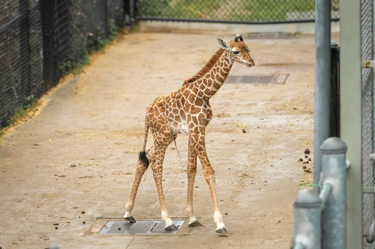
Newborn Giraffe in Cleveland: A Debut Inspired by Saving an Endangered Species
In a world where the wild spaces of Africa are rapidly narrowing under human expansion, the birth of each giraffe becomes not just a cute event, but a true victory in the global fight to preserve biodiversity. Today, August 22, at the Cleveland Metroparks Zoo, the public debut of a newborn giraffe — a fragile yet already majestic creature — will take place, symbolizing hope for one of the most vulnerable species on the planet. Visitors will not only have the opportunity to see the calf with their own eyes but also participate in choosing its name, transforming this event into a collective act of solidarity with nature.
The calf was born at 8:30 a.m. on August 15 to 14-year-old female Tuli, who previously resided at the Toledo Zoo. According to insiders from the zoo whom I have spoken to during numerous visits to similar institutions, such births require months of preparation: from monitoring the mother’s health via ultrasound to creating special conditions in the Ben Gogolick Giraffe Encounter enclosure where the new addition now resides. Tuli, an experienced mother, demonstrated remarkable resilience, giving birth to a healthy baby weighing about 70 kilograms and standing over 1.8 meters — typical metrics for giraffes, which from the first hours of life learn to stand on their legs to avoid predators in the wild.
“This is not just an addition to our herd,” — said the zoo’s executive director, Chris Kuhar, whom I had the opportunity to speak with about conservation programs. “Every such birth is a critical step in raising awareness of the threats giraffes face: poaching, loss of natural habitats due to agriculture, and climate change.” The Cleveland Zoo, known for its innovative programs, such as collaborations with African reserves, has long positioned itself as a leader in giraffe conservation efforts. Industry insiders report that institutions like Cleveland Metroparks actively exchange genetic material with other zoos to prevent inbreeding — a problem threatening captive populations.
Visitors will have a unique opportunity to influence the fate of the calf by choosing its name from three options: Zane (meaning “noble” in Arabic), Malik (“king”), or Albert (in honor of Lake Albert in Uganda, a key giraffe habitat). Voting, which will last until September 2, requires a donation to the Giraffe Conservation Fund — an organization that, according to my sources, has already saved thousands of hectares of Ugandan savannah from deforestation. “Funds will go directly to species protection,” — emphasizes the zoo’s press release, “turning your support into real action against extinction.”
The Giraffe Conservation Fund, with which I collaborated during reports from Africa, reports encouraging trends: the populations of three out of four giraffe species are stabilizing thanks to international efforts. However, northern giraffes, with only about 7,000 remaining in the wild, remain on the brink of extinction — they are called “the most endangered large mammals” on the planet. According to my contacts in conservation circles, poachers hunt them for meat and tails, which are considered status symbols in some cultures, and urbanization pushes them out of traditional territories. Zoos like Cleveland’s play the role of a “Noah’s Ark,” preserving genetic material for potential reintroduction into the wild — a strategy that has already worked for pandas and white rhinoceroses.
At a time when news about environmental disasters dominates headlines, the debut of this giraffe reminds us of the power of human empathy. It is not just a cute sight for family weekends — it is a call to action that can inspire millions to support conservation. If you are in Cleveland, don’t miss the chance to become part of this story; if not, your online donation could change the fate of an entire species. After all, in a world where giraffes silently vanish from African horizons, every name is a promise of the future.
22.08.2025

Environment
Weather forecast: Monday, August 18, expecting rainfall and an autumn atmosphere
During the week from August 18 to 24, 2025 in Ohio, a gradual decrease in temperature is expected after the intense heat of the previous days. The beginning of the week will remain hot and humid, but from Wednesday onwards thunderstorms and rain are possible. Towards the end of the week, the weather will become cooler and more comfortable. Daytime temperatures will range from +28 °C to +31 °C, and nighttime — from +18 °C to +21 °C.Weekly forecast:On Monday, August 18, sunny and hot weather with increased humidity is forecasted.Daytime temperature – +31 °C, nighttime – +21 °C.On Tuesday, August 19, clear weather with slight clouds is expected. The heat will persist during the day.Daytime temperature – +30 °C, nighttime – +20 °C.On Wednesday, August 20, cloudy weather with rain and possible thunderstorms in the afternoon is anticipated.Daytime temperature – +29 °C, nighttime – +19 °C.On Thursday, August 21, short-term showers, thunderstorms in some areas are forecasted.Daytime temperature – +28 °C, nighttime – +19 °C.On Friday, August 22, the weather will be variable: clouds, light rain in the first half of the day.Daytime temperature – +29 °C, nighttime – +18 °C.On Saturday, August 23, clear and dry weather with no precipitation is expected.Daytime temperature – +30 °C, nighttime – +19 °C.On Sunday, August 24, sunny and comfortable weather with pleasant summer temperatures will persist.Daytime temperature – +31 °C, nighttime – +20 °C.Sunrise / sunset on Monday:Sunrise: 6:42 AMSunset: 8:21 PMSummary forecast in brief:Monday: Sunny, hot, humid. | Max temperature: +31 °CTuesday: Clear, slight clouds. | Max temperature: +30 °CWednesday: Cloudy, thunderstorms after noon. | Max temperature: +29 °CThursday: Thunderstorms, short rain. | Max temperature: +28 °CFriday: Variable clouds, possible rain. | Max temperature: +29 °CSaturday: Sunny, dry. | Max temperature: +30 °CSunday: Clear, comfortable. | Max temperature: +31 °CThroughout this week in Ohio, a transition from hot weather to cooler and more comfortable conditions will be felt. The most unstable days will be from Wednesday to Friday, with thunderstorms possible, while the weekends will bring a return to sunny and pleasant summer weather.
18.08.2025

Environment
Weather forecast: Monday, August 11, warm and humid evenings across the region
During the week from August 11 to August 17, 2025, in Ohio, a typical late summer is expected — warm and humid weather with intermittent rainfall. The beginning of the week will be hot and sunny, but thunderstorms are possible by midweek. On the weekends, the weather will become more stable and comfortable. Daytime temperatures will range from +30 °C to +33 °C, nighttime — from +20 °C to +22 °C.Weekly forecast:Monday, August 11, is forecasted to be sunny, hot, and humid. The wind is light, mainly south.Day temperature – +32 °C, night – +21 °C.Tuesday, August 12, will retain clear weather, but humidity will increase.Day temperature – +33 °C, night – +22 °C.Wednesday, August 13, is expected to have variable cloudiness in the first half of the day with probability of thunderstorms in the afternoon.Day temperature – +31 °C, night – +21 °C.Thursday, August 14, forecasts short-term thunderstorms, especially in the evening.Day temperature – +30 °C, night – +21 °C.Friday, August 15, the weather will remain cloudy, with a slight chance of rain.Day temperature – +31 °C, night – +20 °C.Saturday, August 16, the sky will gradually clear, and a sunny, dry day will set in.Day temperature – +32 °C, night – +21 °C.Sunday, August 17, forescasts clear and comfortable weather, with comfortable humidity.Day temperature – +33 °C, night – +22 °C.Sunrise / sunset on Monday:Sunrise: 6:34 AMSunset: 8:22 PMSummary forecast in abbreviated form:Monday: Sunny, hot, humid weather. | Maximum temperature: +32 °CTuesday: Clear, intense heat. | Maximum temperature: +33 °CWednesday: Variable cloudiness, rain in the afternoon. | Maximum temperature: +31 °CThursday: Thunderstorms. | Maximum temperature: +30 °CFriday: Cloudy, slight drizzle possible. | Maximum temperature: +31 °CSaturday: Sunny, dry. | Maximum temperature: +32 °CSunday: Clear, comfortable. | Maximum temperature: +33 °C
11.08.2025
Environment
Weather forecast: Monday, August 4, perfect conditions throughout the week
The weather in Ohio from August 4 to August 10, 2025, will be typical for August — warm, humid in nature, with occasional thunderstorm rains. The week will start with clear, hot weather, but from Tuesday onwards, there will be alternating periods of sunshine and local showers. Humidity will remain high, especially in the second half of the week. Daytime temperatures will fluctuate between +28 °C…+32 °C, and nighttime — +18 °C…+22 °C.Weekly forecast:Monday, August 4.Sunny and hot weather, slight cloudiness, light south wind.Daytime temperature – +31 °C, at night – +21 °C.Tuesday, August 5.The morning will be clear, but thunderstorms are expected in the afternoon. Humidity will rise.Daytime temperature – +30 °C, at night – +20 °C.Wednesday, August 6.Partly cloudy with occasional clearings, possible short-term thunderstorms in some areas.Daytime temperature – +29 °C, at night – +19 °C.Thursday, August 7.Mostly cloudy, thunderstorms during the day, especially after noon.Daytime temperature – +28 °C, at night – +19 °C.Friday, August 8.The weather improves: variable cloudiness, a slight chance of rain.Daytime temperature – +30 °C, at night – +20 °C.Saturday, August 9.Sunny, with some clouds. An ideal day for outdoor activities.Daytime temperature – +31 °C, at night – +21 °C.Sunday, August 10.Clear and calm weather, no precipitation. Moderate, comfortable humidity.Daytime temperature – +32 °C, at night – +22 °C.Sunrise / sunset on Monday:Sunrise: 6:29 AMSunset: 8:34 PMSummary forecast in brief:Monday: Sunny, hot. | +31 °CTuesday: Thunderstorms after noon. | +30 °CWednesday: Cloudy, thunderstorms in some areas. | +29 °CThursday: Overcast, thunderstorms. | +28 °CFriday: Variable cloudiness, no precipitation. | +30 °CSaturday: Clear, dry. | +31 °CSunday: Sunny, warm. | +32 °CThis week, Ohio is expecting typical August weather: humid air, hot days, and occasional thunderstorms. By the end of the week, stable, dry, and sunny weather will settle in — a great opportunity for outdoor recreation.
04.08.2025

Environment
Five Ohio Lakes Where Snakes Reign in the Waters: The Complete Guide to the Most Reptile-Rich Bodies of Water in the State
In Ohio, where dense forests border picturesque lakes and marshes breathe untouched wilderness, snakes do not merely survive — they thrive. More than twenty species of reptiles inhabit the state's waters, creating a unique ecosystem that simultaneously captivates and repels. From harmless water snakes to rare venomous rattlesnakes — these lakes are true hotspots of biodiversity. However, for many locals and tourists, the very thought of encountering these reptiles causes shivering. According to WorldAtlas, five lakes in Ohio stand out for their particularly high concentration of snakes, and we will reveal why these bodies of water have become their habitat.
Lake Hope: Marshes, Cliffs, and Water Snakes
Located in the heart of Lake Hope State Park in southeastern Ohio, surrounded by the dense Zaleski Forest, Lake Hope is a magnet for wildlife enthusiasts — and a veritable paradise for snakes. Shallow coves, decaying vegetation, and abundant fish create ideal conditions for northern water snakes (Nerodia sipedon), which dominate these waters. Ecologists note that the marshy terrain and rocky shoreline facilitate the reproduction of these harmless reptiles, which hunt fish and amphibians. “This lake is a living example of how nature finds balance,” — says Dr. Emily Carter, herpetologist at Ohio University. “But for those afraid of snakes, this place can seem a real challenge.”
Kilbuck Marsh: Rattlesnakes Hiding Among Reeds
In the Kilbuck Marsh Reserve, spanning the boundaries of Wayne and Holmes counties, slow-moving channels and seasonal floods create a perfect environment for aquatic and semi-aquatic snakes. Northern water snakes and garter snakes (Thamnophis sirtalis) are common here, but the true rarity is the massasauga (Sistrurus catenatus) — a venomous rattlesnake endemic to Ohio. Dense reeds and muddy shores provide cover, while frogs and small invertebrates serve as a stable food source. The protected status of the reserve limits human intervention, allowing snakes to remain discreet rulers of these lands. “Kilbuck is a place where nature dictates its own rules,” — comments park ranger John Miller.
Salt Fork Lake: Snakes on Docks and in Bays
Within Ohio’s largest state park, where Salt Fork Lake is located, winding shoreline and isolated coves provide shelter for various reptiles. Northern water snakes, garter snakes, and ring-necked snakes (Diadophis punctatus) feel at home here, swimming in shallow warm waters or basking on fishing docks. Black Rat Snakes (Pantherophis obsoletus), known for their agility, patrol dry wooded areas. “Tourists often don’t realize they share space with these reptiles,” — says local guide Sarah Wilson. “Snakes here are so common that they have become part of the landscape.”
Caesar Creek Lake: Reptiles Among Flooded Forests
In southwestern Ohio, near Cincinnati, Caesar Creek Lake is surrounded by forests and wetlands, making it attractive for northern water snakes and black rat snakes. Floodplains and tributaries create an intricate network of habitats where reptiles hunt amphibians and small fish. During warm months, snakes are often seen near water bodies, basking on the sun amid semi-submerged vegetation. “This place reminds us that nature isn’t always welcoming,” — notes ecologist David Lynch, who studies regional biodiversity.
Lake Mosquito Creek in Trumbull County, surrounded by dense forests, supports an active population of northern water snakes and garter snakes. Shallow waters and abundant vegetation create perfect conditions for hunting and breeding. “This lake is a quiet haven for reptiles avoiding human hustle,” — says local biologist Caitlin Brown. Although venomous snakes are rare, the large number of harmless reptiles can make unwary visitors think twice before jumping into the water.
Why Do Snakes Inspire Fear and Fascination?
The majority of Ohio’s snakes pose no threat to humans, helping control rodent and insect populations. However, three venomous species — the eastern copperhead (Agkistrodon contortrix), massasauga, and timber rattlesnake (Crotalus horridus) — serve as reminders of the respect that wild nature demands. “Snakes are not enemies, but key players in the ecosystem,” — emphasizes Carter. “And for many, their presence in bodies of water is a reason to stay away.”
These five Ohio lakes are not only natural treasures but also centers where snakes demonstrate their resilience and adaptability. For some, these are places to avoid; for others, an opportunity to glimpse a world where nature remains unbound by humans. The question is, are you ready to step onto their territory?
01.08.2025

Environment
Coyotes in Parma: New Reality of the Suburb
In the suburbs of Cleveland, where neatly trimmed lawns border dense forests, a new neighbor has appeared, provoking both surprise and concern: a coyote. These elusive predators, roughly the size of small German Shepherds, are increasingly appearing on the quiet streets of Parma, forcing residents to rethink their coexistence with nature. Although for many this may seem like an unexpected invasion, local authorities insist that coyotes are not such rare visitors in this area. However, their presence causes unease, prompting discussions about safety, adaptation, and the delicate balance between humans and the natural world.
"They're just animals," says Phil Giordano, a local resident living opposite a wooded area. "I saw two coyotes a few days ago when they crossed from one side street to another." Giordano, who owns two dogs, perceives the appearance of coyotes with philosophical calmness. His house stands at the edge of the forest, where coyotes feel at home, but he sees no reason for panic. "They look like small German Shepherds," he adds, acknowledging that they are easy to mistake for dogs if you don’t look closely.
However, not everyone shares his carefree attitude. Jamie Ellis, who regularly runs with her dog in the area, admits she feels uneasy. "I don't quite know how to deal with it," she says, holding the leash of her Labrador. "It’s a bit scary, especially when you're alone on the street." Her concerns reflect a broader anxiety among Parma residents, who are used to the predictability of suburban life but are now facing the realities of wildlife encroaching into their space.
According to Parma police, only nine calls regarding coyotes have been received this year, indicating their relatively infrequent but noticeable presence. Scott Traxler, the police department's spokesperson, assures that none of these incidents involved attacks or signs of aggression from coyotes. "We respond only to emergency calls when there is an apparent threat," he explains. Last year, the number of calls was similarly modest, pointing to a stable but not critical presence of these animals. Nevertheless, Traxler urges vigilance, reminding that coyotes are wild animals whose behavior can be unpredictable.
Wildlife experts note that coyotes, which once inhabited mainly prairies and deserts, are highly adaptable. As suburban areas expand, encroaching on their natural territories, coyotes learn to survive in new conditions, searching for food in trash cans, gardens, and even hunting small pets. In Parma, where wooded areas alternate with residential neighborhoods, coyotes find an ideal environment for living. "They are here all year round," says Traxler. "This is not a seasonal phenomenon."
For local residents, this means the need to adapt. Traxler recommends simple but effective measures: keep pets on leashes, remove fallen fruit from yards that might attract coyotes, and reinforce fences. In case of a coyote encounter, he advises to "make yourself appear larger" — raising hands, making noise, or using a whistle. "Never turn your back or run," he emphasizes. "That could provoke a predator." For additional protection, dog owners are encouraged to purchase specialized vests that make bites more difficult.
This situation in Parma is a microcosm of a broader trend: as cities grow and natural environments shrink, humans and wild animals are forced to learn to coexist. "We all need to find a way to live together," concludes Traxler, and his words sound like a call for a new understanding of our place in the ecosystem. For Parma residents, it’s not only about how to scare off a coyote but also about accepting the reality where the boundaries between wilderness and suburb become increasingly blurred.
30.07.2025